Water is obviously a key resource at any point in history, and this blog will focus upon its influence upon the history of Harting. Water obviously matters in terms of domestic consumption, for drinking, washing, cooking etc., but it also was the prime source of power, particularly until the advent of electricity. For water powered mills, and then later iron furnaces.
That part of Harting south of the Downs was pretty much water free, and so here the only solution was either to import it, catch it from the rain, or dig down for it in very deep wells. This is one reason why settlement was pretty sparse in these areas. But north of the Downs there was a fairly plentiful supply, and in particular from two streams that flowed from the base of the chalk. One of these streams flowed through West Harting Manor, and the other largely through East Harting Manor, although the latter also began in the west.
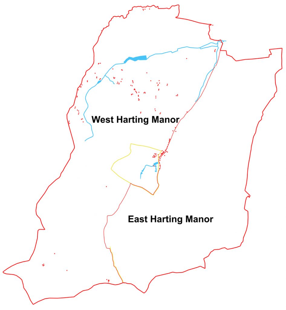
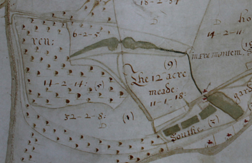
The eastern stream starts within the deer park attached to the Manor House of West Harting, just to the south-west of the modern village of South Harting. Its source is a spring running out of a little combe just to the west of The Warren, the water now flowing via a small pond down into South Gardens just below the lowest of the existing ponds there. However the 1632 map shows the spring being immediately dammed into two larger ponds, separated by a path, which then flow down to a building at the end of the now missing fourth pond of South Gardens. It is this building that is likely to be a mill, and probably a mill whose predecessors date back to Saxon times. In the Domesday Book, the reference to Harting includes a grand total of 9 mills, of which this was almost certainly one. The current ponds in South Gardens, also probably spring fed from the highest pond, may well have developed slightly later as fish ponds – the watery equivalent to the living larder provided by the deer park. After leaving South Gardens, the stream crosses the Chichester road and thus enters into East Harting manor, and out of the range of our 1632 map. Its lower course will be discussed in a later blog.
The West Harting manor stream originates from a spring near Ditcham, again at the foot of the Downs. It flows under the Petersfield Road (B2146) and through what is now Torberry Farm. From there to the River Rother, where it ends, it has an eventful journey, being dammed at least four times for various purposes.
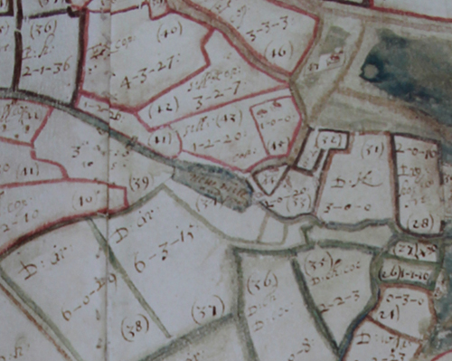
Nowadays the highest dam is that at Hurst Farm, where a mill still exists, although no longer in use. This mill does not appear on the 1632 map, but is there by the date of the 1st Ordnance Survey edition of 1808. Further down stream there was an earlier mill, confusingly called “New Mill” which ironically now no longer exists. It used to lie in Goose Green, in angle between the road to Ryefields and that to Manor Farm, with the mill building located at the eastern end of a small rectangular pond, and several other buildings forming a small hamlet to the west.
Further downstream again we find what is now called “Harting Pond”, a much larger body of water. There is no sign of a building on the 1632 map in the vicinity of the pond’s dam, and no writing to indicate what its original purpose was. The most likely explanation is that it was the site of another of Harting’s nine medieval mills, but without further evidence this remains uncertain.
We are on firmer ground with the next pond, although this time, conversely, no pond survives, but a name does. For on the 1632 map the words “Furnace Pond” are written over the area between channels of the West Harting stream, just as it exits the modern parish and enters Rogate, to the north-west of Nyewood. As the name suggests, this was not the site of a mill, but rather of an iron furnace, or more properly an iron hammer. The buildings of the hammer probably lay at the far eastern edge of the pond, inside the parish of Rogate, with the water backing up all the way to Parlour Copse or even Down Park Farm. Iron hammers tend to work in partnership with iron furnaces, with the latter extracting the ore from the rock and the former hammering it to produce a more marketable iron product. The pair for this hammer lay to the north in what is still called Harting Combe, although it lies now in Rogate parish, for here the site lay over the Weald clay, in which the ore can be found, whereas the hammer is over the Gault Clay, which does not contain ore.
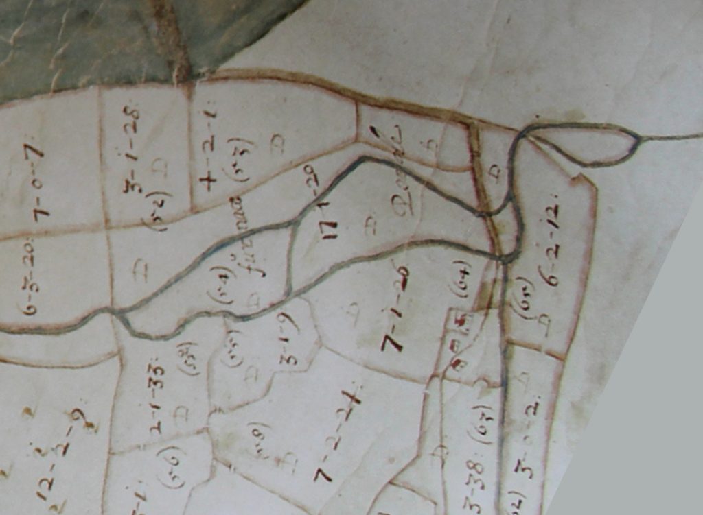
The hammer and furnace were in operation from about 1588-1608, a relatively short period, perhaps suggesting that they were not very profitable, certainly compared to the many others that lay further into the Weald to the east. If you want to see the site of a furnace that lasted much longer and survives much better, then North Park Furnace at Fernhurst is the place to go (they have an annual Open Day in September which is well worth a visit ( http://www.fernhurstfurnace.co.uk).
Shortly after the hammer, the West Harting stream empties into the Rother, just to the west of Habin bridge, by Mizzards. And so also ends this blog ,except to observe once again that water meant power in centuries past, and a power that you could just keep on exploiting, building more and more dams to control and use its flow to power mills and furnaces. And the power was not just in the water, for whoever owned the water could make significant sums of money as a result of selling the produce of those mills and furnaces.