Writing on water for the last blog post has got me onto thinking about the landscape more generally. A good way to get your head around how a particular locality might have been lived in over the centuries is to strip out all the works of mankind and start again with a blank canvas. The bare bones of a landscape are essentially the topography (i.e. the hills, valleys, plains etc.), the water (springs, streams, rivers) and the geology (what is beneath the ground). Everything above that, particularly in an intensively inhabited place like England, is going to be either created or planted by people.
I find the easiest way to do that is to get hold of an Ordnance Survey Explorer 1:25,000 map (the common walking map) which has the contour lines marked on it, and then just trace over the contours (you can do this digitally or manually). That will give you the topography. You can then also trace over the springs, streams and rivers, which will give you the water. For the geology, we are blessed with the British Geological Survey, whose website contains a “Geology Viewer” which plots all the different geologies in the UK, and you can again just trace them off as appropriate (http://mapapps.bgs.ac.uk/geologyofbritain/home.html?)
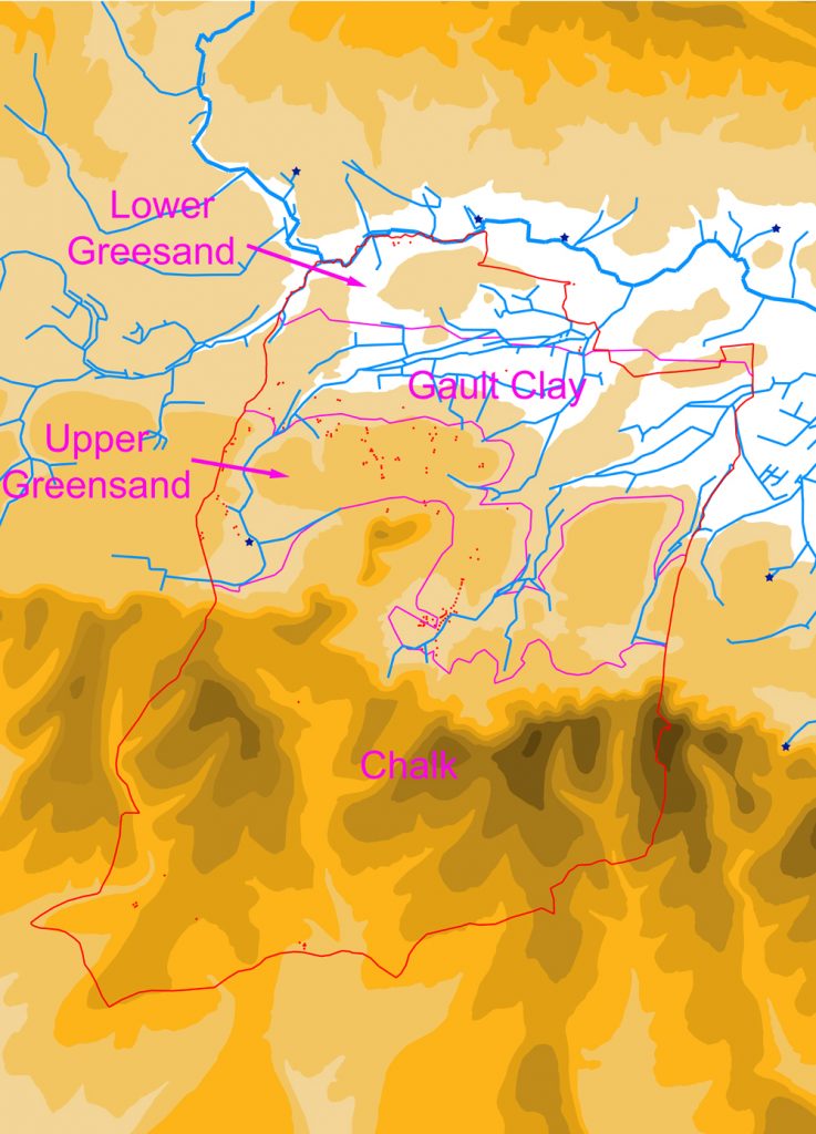
When you have finished doing this you will end up with something like this:
This exercise presents you with a picture of what the first settlers would have encountered, when they turned up, in terms of the “base layers”. Obviously the vegetation above is not so easily demonstrated, since we simply do not have enough data to be certain of what it looked like. The traditional view was that the whole lot was covered by trees, before man came and cut them all down, but voices have been raised to question this, and it is not impossible that the landscape was in fact rather more varied, with potentially quite large open spaces grazed by herds of animals.
Returning to the three elements of our base map, we will start with geology. Harting, like many of the Sussex parishes, has a wonderfully mixed collection of geologies, with the chalk Downs in the south, sloping steeply down to the shelf of Upper Greensand upon which the villages of West, South and East Harting sit, which in turn dips down to the Gault Clay, with Nyewood upon it, and finally the Lower Greensand, through which the River Rother meanders.
Each of these geologies has its own characteristics, but the main interest for us is those that effect what people do. The chalk is well-drained, with generally thin, easy to cultivate soils. The Upper Greensand is moderately well-drained (there is a varying clay content) and the soils are more fertile. The Gault clay is generally pretty horrible, being too wet in winter and too dry in summer, because of its poor drainage. The Lower Greensand is well-drained, and of middling fertility.
A glimpse at the Google Earth aerial photos will give you a pretty good idea of how farmers now use these different soils, so you will see mainly pasture over the highest Chalk slopes and over the Gault Clay, and then mainly arable over the Upper Greensand and lower southern chalk slopes. The Lower Greensand is slightly more mixed, with some arable and some pasture. While we have to make some allowance for improved methods of ploughing and more effective fertilisers, modern use is not a bad guide to past use, and it seems likely that back in the day cultivation followed roughly the same pattern. The one exception seems to have been that the thin chalk soils on the upper slopes of the Downs were more heavily used for cultivation, probably because they were easier to plough, but we will return to that in a later blog.
It is striking also to note that the vast majority of settlement seems to have squeezed onto the Upper Greensand shelf, probably because the Downs had no water, the Lower Greensand was too low lying and, frankly, no-one wanted to live on the Gault Clay (sorry residents of Nyewood). Again, this may have been different in the case of the chalk in the further past, as we will discuss in that later blog.
Water we have looked at a bit already, but the map above shows that within the eastern half of the parish, as well as the west, and so you can see the fate of the “east stream”, as it leaves West Harting Manor at the base of South Gardens and makes its way north-eastwards to exit the parish on Dumpford Lane. There is a third stream right up against the parish’s eastern boundary, starting close to the bend in the Elsted road, flowing through Sheepwash Copse and exiting into Elsted parish shortly afterwards. Because of its relatively short length within Harting, it does not have the same significance as the other two streams, which were both heavily exploited, as was that short stretch of the Rother that forms the north-western boundary of the parish. As has been stated, once you hit the Downs, water disappears, and any settlement upon them has to make use of deep wells, seasonal ponds, or simply hard grind in lugging water up the hill.
The final element, the topography, is the most striking. Essentially the parish runs down in a series of steps to the Rother from the north scarp of the Downs, but then slopes down more gradually from the same scarp to the south, over the back of the Downs.
Two key factors are immediately apparent, the first being transport. Put simply, how do you get from one end of the parish to the other, particularly over the Downs. Here the contours can really help in predicting where people might, in the past, have done this. The lowest point over the Downs in Harting parish, for example, is clearly where the current Compton road runs, although the valley it uses does fork as it approaches the scarp from the south, with one arm running down to South Harting, and the other running round the west of Hemner Hill. But I will be looking at roads in another later blog.
The other key factor which the topography throws up is settlement. We have already seen the position of most of the current villages, sitting as they do upon the Upper Greensand shelf. Outside of this, settlement is limited, and there has to be a good reason for it existing elsewhere. For example Nyewood has its origins as a railway hamlet, but you will see that even then, that it sits upon a spur of higher land sticking out into the Rother valley, or in the case of the houses at Durford Mill, they are obviously there because of the mill.
I am sure you can draw many more conclusions from studying this base map youselves – some of which I hope to look at in the future. Do feel free to make comments/suggestions, or, if you wish, requests for the subject matter of later blogs.